 Forecasters have issued warnings of potentially life-threatening flooding along the US East Coast as Hurricane Erin continues to strengthen.
The storm, now a Category 3 hurricane, is expected to expand as it tracks northward through the western Atlantic. While Erin is not projected to make landfall, it is forecast to generate dangerous waves and rip currents affecting the Bahamas, Bermuda, the US East Coast, and Canada’s Atlantic shoreline.
A tropical storm warning remains in place for the Turks and Caicos Islands and parts of the southeast Bahamas. In North Carolina’s Outer Banks, a storm surge watch has been declared amid growing concerns over high surf and powerful winds.
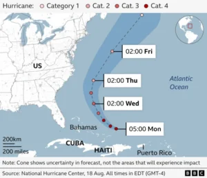
According to the US National Hurricane Center, Erin’s center is expected to pass east of the Bahamas on Tuesday before moving northward between Bermuda and the US East Coast on Wednesday and Thursday.
Authorities in the Outer Banks have ordered mandatory evacuations for Hatteras and Ocracoke Islands, warning that the main highway connecting them to other islands could soon be rendered impassable by rising waters.
Map: Predicted path of Hurricane Erin

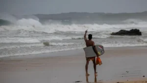
Swimmers and surfers have been warned of deadly rip currents forming along much of the US East Coast, as Hurricane Erin continues to churn through the Atlantic. Rip currents – powerful flows of water moving away from shore – can quickly drag people out to sea, and local media reported dozens of rescues on Monday at Wrightsville Beach in North Carolina.
Meteorologists describe Erin as “unusually large” and forecast it will grow further in size. As of 05:00 local time (09:00 GMT), the hurricane was producing sustained winds of 115mph (185 km/h).
BBC Weather’s lead presenter Helen Willetts cautioned that while Erin is not expected to make landfall, it could still bring “considerable rainfall leading to flash flooding, coastal flooding from storm surge, wind damage and dangerous rip currents.” She noted that Puerto Rico has already seen 82mm of rain in just 24 hours, while Anguilla recorded 62.3mm.
Erin, the first hurricane of the 2025 Atlantic season, “explosively intensified” into a Category 5 storm on Saturday before weakening slightly but continuing to fluctuate in strength.
In Turks and Caicos, authorities suspended public services on the largest island and urged residents in at-risk areas to prepare for possible evacuation. Meanwhile, in Puerto Rico, more than 150,000 people lost power after high winds damaged electricity lines. The local energy provider, Luma, said emergency repairs had restored service to 95% of customers by Sunday evening.
